English
  Français
Compare

TerrusM
| Category | SLAM |
| Topic | SLAM 3D scanners |
| Technology | Laser pulse |
| Max. resolution | - |
| Country | Australia |
Price
Approximate starting prices based on supplier-provided information and public data. Prices may vary by region, over time and do not include additional products or services (taxes, shipping, accessories, training, installation, ...).
upon request
Description
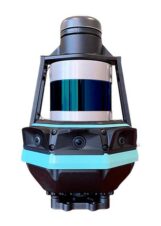
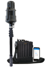
AutoMap TerrusM overview
The TerrusM is a slam 3D scanner produced by AutoMap, a manufacturer based in Australia.
The TerrusM AutoMap uses the laser pulse technology.
AutoMap TerrusM price
Please contact us to get a quote.
Technical specifications
General |
|
|---|---|
| Model | TerrusM |
| Brand | AutoMap |
| Price
Approximate starting prices based on supplier-provided information and public data. Prices may vary by region, over time and do not include additional products or services (taxes, shipping, accessories, training, installation, ...).
|
upon request |
| Release date | 2021 |
| Country | Australia |
| Status | Available |
| Category | SLAM |
| Topic | SLAM |
| Technology | Laser pulse |
| OS compatibility | - |
Performance |
|
|---|---|
| Max. resolution | - |
| Max. accuracy | 20 mm |
| Volumetric accuracy | - |
| Acquisition speed | 600,000 points/s |
Hardware |
|
|---|---|
| Dimensions | 150 × 150 × 260 mm |
| Weight | - |
Features |
|
|---|---|
| Texture/Colors | |
| Wireless | - |
| Robotic arm | - |
| Enclosed | - |
Connectivity |
|
|---|---|
| USB | |
| Wifi | |
| Bluetooth | |
| SD card | - |
| Ethernet | - |

Related products
SelectionThis product is featured in a buyer's guide.

From
Approximate starting prices based on supplier-provided information and public data. Prices may vary by region, over time and do not include additional products or services (taxes, shipping, accessories, training, installation, ...).
$ 65,000
SelectionThis product is featured in a buyer's guide.

Price
Approximate starting prices based on supplier-provided information and public data. Prices may vary by region, over time and do not include additional products or services (taxes, shipping, accessories, training, installation, ...).
upon request
SelectionThis product is featured in a buyer's guide.

From
Approximate starting prices based on supplier-provided information and public data. Prices may vary by region, over time and do not include additional products or services (taxes, shipping, accessories, training, installation, ...).
$ 49,000
SelectionThis product is featured in a buyer's guide.

From
Approximate starting prices based on supplier-provided information and public data. Prices may vary by region, over time and do not include additional products or services (taxes, shipping, accessories, training, installation, ...).
$ 90,000
SelectionThis product is featured in a buyer's guide.
From
Approximate starting prices based on supplier-provided information and public data. Prices may vary by region, over time and do not include additional products or services (taxes, shipping, accessories, training, installation, ...).
$ 60,000

HERON MS TWIN Color
Gexcel
Product data validated by the manufacturer.
Price
Approximate starting prices based on supplier-provided information and public data. Prices may vary by region, over time and do not include additional products or services (taxes, shipping, accessories, training, installation, ...).
upon request

HERON Lite
Gexcel
Product data validated by the manufacturer.
Price
Approximate starting prices based on supplier-provided information and public data. Prices may vary by region, over time and do not include additional products or services (taxes, shipping, accessories, training, installation, ...).
upon request
HERON Lite Color
Gexcel
Product data validated by the manufacturer.
Price
Approximate starting prices based on supplier-provided information and public data. Prices may vary by region, over time and do not include additional products or services (taxes, shipping, accessories, training, installation, ...).
upon request

From
Approximate starting prices based on supplier-provided information and public data. Prices may vary by region, over time and do not include additional products or services (taxes, shipping, accessories, training, installation, ...).
$ 49,000

Price
Approximate starting prices based on supplier-provided information and public data. Prices may vary by region, over time and do not include additional products or services (taxes, shipping, accessories, training, installation, ...).
upon request

From
Approximate starting prices based on supplier-provided information and public data. Prices may vary by region, over time and do not include additional products or services (taxes, shipping, accessories, training, installation, ...).
$ 35,000

Price
Approximate starting prices based on supplier-provided information and public data. Prices may vary by region, over time and do not include additional products or services (taxes, shipping, accessories, training, installation, ...).
upon request