Compare

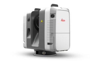
Leica RTC360
| Category | Terrestrial |
| Topic | Terrestrial 3D scanners |
| Technology | Laser pulse |
| Max. resolution | - |
| Country | Switzerland |
From
Approximate starting prices based on supplier-provided information and public data. Prices may vary by region, over time and do not include additional products or services (taxes, shipping, accessories, training, installation, ...).
$ 80,000
Description
Leica Geosystems Leica RTC360 overview
The Leica RTC360 is a terrestrial 3D scanner produced by Leica Geosystems, a manufacturer based in Switzerland.
The Leica RTC360 Leica Geosystems uses the laser pulse technology.
Leica Geosystems Leica RTC360 price
This 3D scanner is available from $ 80,000.
Technical specifications
General |
|
|---|---|
| Model | Leica RTC360 |
| Brand | Leica Geosystems |
| Price
Approximate starting prices based on supplier-provided information and public data. Prices may vary by region, over time and do not include additional products or services (taxes, shipping, accessories, training, installation, ...).
|
upon request |
| Release date | 2018 |
| Country | Switzerland |
| Status | Available |
| Category | Terrestrial |
| Topic | Terrestrial |
| Technology | Laser pulse |
| OS compatibility | - |
Performance |
|
|---|---|
| Max. resolution | - |
| Max. accuracy | - |
| Volumetric accuracy | - |
| Acquisition speed | - |
Hardware |
|
|---|---|
| Dimensions | - |
| Weight | - |
Features |
|
|---|---|
| Texture/Colors | - |
| Wireless | - |
| Robotic arm | - |
| Enclosed | - |
Connectivity |
|
|---|---|
| USB | - |
| Wifi | - |
| Bluetooth | - |
| SD card | - |
| Ethernet | - |
 English
  Français


